Sunday, November 04, 2012

Ecuador Rivers Update November 1st 2012

Hey Kayakers,

Here is an update on a few of Ecuador's rivers from October/November 2012.  

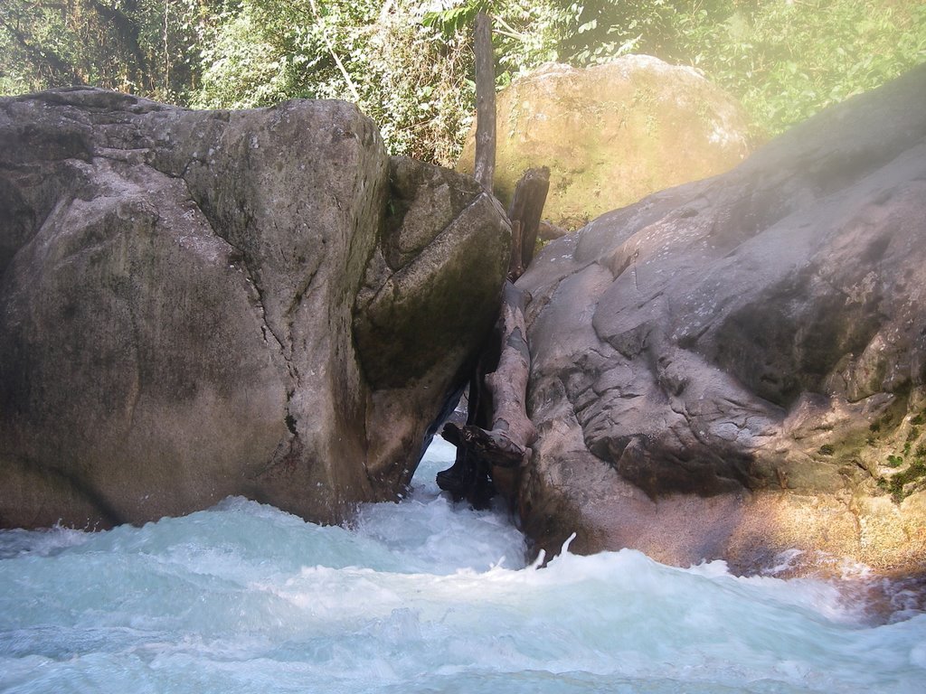
The most important one: There is a new and, in my opinion, very dangerous log on the Upper Jondachi.   It is right below the put in foot bridge if you walk in at Kilometer 28.  Right now, the put in bridge is in major disrepair and most sane people won't want to walk across it.  So, there is a put in trail on river left which leads you to the middle of the rapid with the log.  You would need to then walk back upstream to run the part of the rapid where the log is.  I have included a photo here and the black line represents the log.


The log is rather hard to see as only the right 10 inches or so are sticking out of the water (at fairly low water).  At medium to high flows, it will be completely covered.  The log blocks your path to the right boof in this drop.  When running the middle line here, it's very easy to get subbed out in the seam--this is where the log will be very dangerous.  Again, at medium to high flows you won't see it--but the bulk of the log runs down into this seam.  A kayaker who subs out here will run a high chance of having their bow go under the log and getting pinned.  So be careful out there kayakers!  Personally, I'm going to walk this drop until I know the log is gone.

There were actually quite a few new logs on the Upper Jondachi, but most you can see in ample time.  There was just one other tricky one.  It's below "Sideways Boof" (the rapid pictured above) by a few hundred meters.  For more of a reference, "Sideways Boof" is just a little ways downstream of Aphrodesia.  The log is in a non-descript rapid just before you get to a sketchy, decrepit bamboo foot bridge.  The river squeezes down to one small channel (where the main flow goes) and the log lays across this channel--really the only place for a kayaker to go.  At low-ish water, we were able to paddle over the log, but if you are in there at REALLY LOW flows, you'll have to portage. 

Ok, what else...The access to the Urcusiqui River (put in #2 in the guidebook) has a new and very large sign saying Private Property No Access.  The gate was NOT locked, but the sign makes it pretty clear that they don't want people in there.  So, we respected their wishes and hiked in at KM 28.


The Upper Mis river was more or less unchanged, but the big news is that the Lodo put in is no longer full of Lodo!  There is now a gravel road that gets you all the way to the river.  Follow the same directions that the guidebook has, but now you no longer need to hike.  When the book says, look for the trail, just look for the gravel road and then drive all the way to the foot bridge over the Misahualli.

Piatua river and access are the same as last year.

There were many more changes in the Quijos Valley.
There must have been some big floods while we were gone!  The Oyacachi River has tons of small changes.  But the overall character is still the same and the run is still awesome!

On the Cheesehouse section of the Quijos, the rapid shortly after the put in--where they have done tons of construction and basically re-routed the river has changed for the worse.  Last year this rapid was different every time we paddled the run, and I assume the same will be true this year, so I think it's always worth a scout.  Moving further downstream, sadly, one of my favorite boofs is gone--the one below the 3 Marias waterfalls--but it's been replaced by a harder, more intricate rapid.  So, all and all a gain.   Lots of other small changes, but nothing of note to a person who has never been there before!

Cosanga, all accesses are the same.  The rapids have quite a few changes, and there's a couple new logs, but they are relatively easy to see from upstream. 2 logs of note:

1.) There is a log in the boof at Chibolo--sad :-( 
But there is a route around the boof. 

2.) Then, there is also a bad log in the rapid just above where the Rio Bermejo joins the Cosanga.  There is a large divider boulder at the bottom of this rapid.  The log is stuck on the boulder and juts out into the left channel.  If you take the right channel, you'll be in the clear.  If you are being a smart boat scouter, you'll see this log with plenty of time to avoid it, but be careful!

Ok, moving onto the Papallacta.  This river is a bit messed up right now due to the hydro project they are building here.  


We paddled this run on a holiday and so the construction crews were NOT working.  If they were working while you wanted to paddle the run, I'd recommend chatting with them (although you may run the risk of them denying you access to the river).  But, from the put in down about 1 km they've made a very unnatural river bed--a sort of very narrow hallway if you will.  If they were moving earth while you happened to paddle by, it's very conceivable you'd get a back hoe load on the head.

After you get through the 1st construction zone, the river is relatively unchanged down to the 2nd construction zone--about 1/2 way through the run.  Here, you'll have to deal with more man-made river bed issues.  Then, the 3rd construction zone is at the confluence with the Quijos.   They've changed the confluence rapid A BIT.  It's still runnable, but stopping above the bride is recommended to get out and  make sure that they aren't actively working in/near the rapid, etc...If you need to, you can take out just upstream of the bridge on river left and walk down the newly constructed road to the Quijos River and put back in.

When we ran the Papallacta, it was 4 on the gauge and this is about as low as I'd want to go.  Lower would be possible, but you are going to beat the crap out of your boat!  Take the gauge readings with a grain of salt because the gauge is in the construction zone--about 100 meters downstream of the put in bridge on river right--and I'm sure the area around the gauge will be constantly changing as they work.   But you can get an idea of our flow from the photo above.

Here are a couple more photos of the Papallacta just to remind you that it's still a sweet run!


The Take out for the Lower Quijos is currently "off limits" to kayakers due to the dam construction for the Coca-Coda Sinclair project.  I'm sure if you showed up there in your kayak, they will have to let you leave (walk to the road) but just be aware that it is a major construction zone down there.  It is possible to take out now on river right a little less than halfway down the Lower Quijos.  This does shorten the run considerably and will be an expensive shuttle, but if you really want to face Gringos Revueltos, this is an option!  After you run Gringos, you'll head downstream about 1 more kilometer and then take out on river right.  From the river, as you are running down river, you'll come to an island, take the right channel and eddy out above the wall shot.  Then you'll see the road.  You MUST hire a taxi if you are using this access, no buses run here.  It will, honestly, be a little tough to explain the take out to a taxi driver if they've never picked kayakers up there before.  Tell your taxi driver to pick you up on the Via Muradillos.  They cross the Bom Bon bridge, drive through the town of Bom Bon and then downstream on river right.  The place where the driver can access the river is just after the road crosses a small stream.  There is no bridge, the driver will just drive through this small stream.

That should do for now.  If anything major changes during the season, we'll update this again.  You can check our facebook page for daily water level updates throughout our season.

 Happy Paddling!


Sunday, November 07, 2010

Updates November 7th, 2010

Before continuing to read this blog, just remember that the rivers are always changing here in Ecuador, so after the next big rainstorm, this info may already be outdated.
Boat cautiously and scout often if things look weird, or go with a guide or friend who knows the rivers!

Now, onto what we know on Nov. 7th, 2010.

I would say that every run has lots of subtle changes; but there are very few big changes. We were quite surprised to find that more had NOT changed in Tena after the big floods they got. While the rivers there are somewhat different, we were expecting more complete changes.

So, here's a list of things to note:

Jondachi/Hollin: There was a new landslide on the Hollin River below the rapid called "waffle-era." It seems to be constantly changing, so scout it! It was runnable last week, but the rapid is super unstable and will most likely change with each rain event.

Upper Jondachi: The biggest rapid of note is the Old Sticky Fingers. At the level we saw it at (a little over 1 on the gauge) the rapid was all but unrunnable. A new rock blocks the right hand run and stuffs you into an overhanging AND undercut boulder on the right. For those who don't know the names, Sticky Fingers is probably a little over an hour into the run (depending on how often you scout). The bummer is, it's a pretty innocuous rapid that is easy to blunder into. So, if you or your group doesn’t know the run, just scout whenever you are unsure.

The sieve at Tres Huevos has also opened back up, but the normal line is still ok to run. Just be careful of the sieve if you are eddy hoping and trying to get to the last eddy on river left to scout. Personally, I'd just take out 1 or 2 eddies up to scout--you'll want to run from up here anyways.

Typhoid Falls was more or less the same. The 2nd drop has an avoidable tree in it, but it makes getting to the middle exit slot quite difficult, and the right slot ain't that good!

Rio Quijos: Nothing major really. The 1st rapid of Cheesehouse where they’ve been working burying the pipeline will probably need to be scouted each run this year. They don’t seem to be working there anymore, but the “unnatural” river channel they’ve made is made up of lots of dirt and small rocks and I imagine things will be shifting in there for a long time.

Cosanga: The first real rapid of the Lower Cosanga has changed for the worst (it’s the one we call triple drop). There are lots of rocks in the way of where you want to go. So, boat scout well, or scout this one.

Nothing more of note to report here. Lots of small changes on the Piatua, Misahualli, Oyacachi and other rivers, but you’ll figure them out once you get there!

Happy paddling.


Monday, December 28, 2009

Piatua


A couple of years ago a new road was built up to a small village on the banks of the Rio Piatua--a tributary of the Anzu River. This road opened up boating access to the Piatua River, which is a wonderful new addition to Tena's repertoire of runs. Here's the beta:


Class

Low IV-
Med IV
High IV+


Time 3.5 hours
Gradient 110 fpm
Length 10K
Rafts NO


Character Technical river run

Fiesta Factor 4 Beers


Degree of suffering 3 Skulls Long drive to put in


Medium flow 1000 cfs

Shuttle Truck taxi to put in, bus home is possible


Description
The Piatua is a user friendly, warm, clear water river full of round boulders set in a beautiful rainforest environment. The river is a fun mix of lots of class III boulder gardens with the occasional more challenging drop. The advanced boater can probably boat scout everything, but less experienced paddlers will either want to hop out occasionally or follow someone who knows the lines. Although it is not a creek, most of the moves require creeking technique since boofs, slots, and pillow moves abound.

Put-in
The best way to get to the put in is to hire a taxi since no buses run up the road that crosses the bridge at the take out for the Upper Anzu (see page 74 of the guidebook). The bridge across the Anzu is super low clearance so hop out and be sure your boats fit under the west end of the bridge structure. From Tena, head towards Puyo. Then, find the bridge over the Anzu that is the take-out for the Upper Anzu, cross the bridge and head up the dirt road for about 40 minutes or so. The drive to the put in is an hour and a half from Tena. The first half of the drive is on a great road but the last half is a pretty bad dirt road. When are you getting close to the village, you will start to see some little houses. Then, there is an obvious road cut that goes off to the left. Have your taxi park here. From this pull in walk about 5 meters down the road until a major "trail" (it almost looks like the start to another road) goes off to the right. Follow this down to a bridge across the Piatua. The easiest way down to the river is to cross the bridge and look for a trail on the upstream side of the bridge (so you are putting in on river left).

Not recommended put-in
It is possible to drive all the way to the small village and put in here. But, there is really no sense in doing this as it is such a short hike if you use the preferred put in (described above). The problem with this one is that the some of the village inhabitants expressed displeasure in kayakers changing and walking through their remote village. By using this put in, you not only miss a bit of fun whitewater, but you also run the risk of leaving a bad impression on the locals. We figure it's better to respect their wishes, and just use the put in before you actually get to their village.

Take-out
Once you hit the Rio Anzu you should ferry almost straight across to a little beach just downstream of the overhead cable. Have your taxi meet you there or walk the two minutes to the road to catch a bus for the 40 minute ride to Tena. To find this take-out from the road it's easiest to drive to the bridge across the Anzu that you'll take to the put in. Then, from here, back track on the main road to Tena about 5 minutes and look for a small road going off to the left. This road is only about 100 meters long and takes you right to the river.

It's also possible to take out at Cabanas Piatua on river right just after a bridge with a rope swing. They may charge you a user fee to take out here, and your taxi will have to drive slightly further. The normal take-out is only about 10 minutes further downstream from Cabanas Piatua.

Saturday, March 22, 2008

KAYAKING IN ECUADOR--AN UPDATE

Upper Jondachi update from the 2007/2008 Season: Big Flooding Changes Thing Up Yet Again A big flood in early February scrambled things around in the Upper Jondachi. Most of it was for the better. You can see by the large pile of logs in this photo that the water got kind of high!


One of the most drastic changes was the rapid directly upstream of the put in bridge. You can see from this photo that most of the water is now going to the river right of the big rock at the bottom and the left channel is blocked by logs and other debris.This is a shot of the entrance. The slot on river left up against the wall used to be a nice 6-8 foot boof. Now it's 1-2 feet tall and leads to some problematic logs.
Here is another overview of the entire rapid. The good news is, it's still runnable even though it's not quite as classic as it used to be. Right entrance, right exit is pretty nice now. Tres Huevos was also changed in the flood. On a previous post on this blog we reported that it has changed for the worse with the sieves between big boulders (huevos) opening up. Well now, those sieves are all plugged up again and the rapid is back to it's good ol' self again. The right entrance is super nice now and the same right exit is back.


Tres Huevos from downstream.


The last change of real note is Typhoid Falls. In an earlier flood this year, a massive siphon opened up in the middle of the rapid. This siphon is now clogged back up again, but the exit to the rapid has a log in the channel where all the water wants you to go. This photo is looking down stream just below the actual Typhoid Falls which is runnable. Most of the water pushes into this right hand channel which looks clean from upstream, but there is a VERY NASTY log blocking the exit. Last time we were there the left exit channel was clean, but things change fast down there. Definitely scout or portage.
Stay tuned for a new write up on the Piatua River.

Sunday, December 31, 2006

Wood in Tres Huevos


Here is a photo of the wood blocking the middle channel of Tres Huevos on the Upper Jondachi (see previous post for a more detailed explanation).

Sunday, December 24, 2006

THE GOOD, THE BAD, AND THE UGLY--RIVER CHANGES FOR DECEMBER 2006

THE GOOD, THE BAD AND THE UGLY

Rio Jondachi December 2006
The upper Jondachi is as wonderful as ever but there are some changes from last year.

THE GOOD: Sticky Fingers has blown out and changed from a nasty hole where, if you chumped your boof, you were almost guaranteed a sticky swim. Now it has blown out and the right side is a straight class III move. Some people may lament the loss but I’m not one of them.
THE BAD: A few of the cool boofs are gone as well as one on river right about a half hour down has a tree in it.


THE UGLY: Tres Huevos is back to its old form with an almost unrunable line on the right. In the old days if you felt the need to try that side and blew it, you would have a good chance to wash left and run through a little tunnel between the left and middle huevo (huge boulder). Unfortunately that slot is now full of logs. Be good or eat wood! I found the river left portage quite nice.


UPPER RIO MULATE River time change. The on-river time for the Upper Mulate should be 4-6 hours (a wee bit longer than we originally thought). Don’t let that phase you though, it only means you have longer to enjoy it. I would give it a class IV rating even at low water as well.

QUITO – TENA ROAD WORK: Dec 2006. The good news is that they are back to working at least on a limited scale on the road between Baeza and Tena. The bad news is that the work is causing some traffic delays. So far they workers haven’t settled into a set schedule of times when you can get through. Around lunch time is usually a good bet and so far we haven't had to wait over an hour during the morning.

For more info, or to plan a trip check out www.smallworldadventures.com or e-mail info@smallworldadventures.com

Thursday, November 23, 2006

HOT OFF THE PRESS

Hello Kayakers,

The 2nd Edition of the Kayaker's guide to Ecuador is hot off the press.
To order your copy e-mail or call the Small World office 1-800-58-Kayak or
info@smallworldadventures.com


It looks much better in real life! It's hard to shoot good photos
of books in dark and dreary British Columbia.

Don and Larry have been in Ecuador for almost a month now, and they are reporting excellent water levels, sunshine, and ample bird life. No major changes on the runs that they've noticed so far. The Lower Mis. portage is still a grunt up into the jungle, and the rest of the run is still as great as always!